

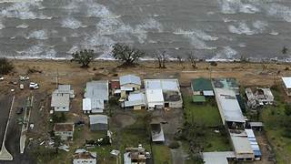
Queensland’s north tropical coast will be affected by Tropical Cyclone Jasper, and that will be life-threatening. The nation’s Bureau of Meteorology stated that category 2 tropical storm Jasper is predicted to reach landfall on Wednesday, posing a threat with flash floods and severe wind gusts.
Tropical Cyclone Jasper is anticipated to affect the coast and mountains between Cape Flattery and Port Douglas, as well as locations close to the storm’s centre. Tropical Cyclone Jasper has the potential to inflict life-threatening flash floods.
destructive wind gusts:- Queensland’s north tropical
“From early Wednesday morning, destructive wind gusts of up to 140 km/h may develop between Wujal Wujal and Innisfail, including Cairns.” Category 2 tropical cyclone Jasper may develop a little bit further as it moves closer to the shore.
History of devastating Tropical Cyclone in Australia Queensland
Tropical Storm On March 23, Jasper developed into a tropical low in the Coral Sea. Early on March 24, the low formed a southeasterly track away from the coast of Queensland and strengthened into a tropical cyclone.
Locals refer to the tropical storm Jasper as the mother of all cyclones. Though Tropical Cyclone Jasper is the first December cyclone in the Coral Sea during an El Niño year, residents of North Queensland are scarcely unfamiliar with the phenomena.
Cyclone Debbie – March 2017 – In March 2017, Debbie, a strong category 4 cyclone, made landfall close to Airlie Beach after passing over the Whitsunday Islands. Numerous people died as a result of the floods, which forced large-scale evacuations from south-east Queensland and New South Wales. The most expensive cyclone in Queensland history is Debbie.

Cyclone Marcia
Cyclone Marcia – February 2015 – When Marcia crossed the shore in Shoal water Bay in central Queensland, it reached category 5 strength. Over 2,000 houses sustained damage. Marcia abruptly veered from the predicted route.
Yasi caused immense destruction in its path and was the biggest storm in Queensland’s history. Up to 285 kilometres per hour of projected wind gusts were brought by the category 5 system that crossed the coast close to Mission Beach.
What causes Tropical Cyclones
- Elevated water temperatures, no less than 27°C.
- Converging winds close to the ocean’s surface push air upward, creating storm clouds.
- Low wind shear winds, which do not change much with height.
- Enough separation from the equator to allow a spin, such the Coriolis force, to operate.
This tropical storm is finally posing a threat to life. If you or anyone you know is in danger, dial triple zero (000). For assistance during a cyclone, contact the SES at 132 500 or download the SES Assistance OLD app
