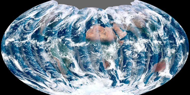
The stunning global picture of the earth captured through the NOAA-21 Visible Infrared Imaging Radiometer Suite (VIIRS) instrument’s first picture has been made public by the National Oceanic and Atmospheric Administration.
A breathtaking panoramic image of the Earth was made by the recently launched satellite using data from swathes of the whole globe collected over 24 hours between December 5 and 6.
Unlike geostationary satellites, polar-orbiting satellites observe the entire earth twice daily. The mosaic image, according to the CIA, depicts moving weather systems, pollution from agricultural fires in Northern India, and dazzling blue water in the Caribbean Sea that contains phytoplankton.
Earth:-2022: Out Of This Earth Space Stories
According to a press release from Dr. Satya Kalluri, program scientist for the Joint Polar Satellite System, silt in the shallow waters near the continental shelf is what gives the area around Cuba and the Bahamas its turquoise hue.
Polar-orbiting satellites, as opposed to geostationary satellites, monitor the entire world twice a day and collect data over the entire globe. This worldwide mosaic was made using a composite image of these areas over a 24-hour period between December 5 and December 6, 2022, using data from the VIIRS instrument on board the recently launched NOAA-21 satellite.

Earth:-OFFICIAL SAYS MICROMETEORITE STRIKE IS LIKELY TO BE THE CAUSE OF THE RUSSIAN SPACE CAPSULE LEAK
Additionally, VIIRS produces important environmental products on the health of the world’s crops, clouds, fog, aerosols, and dust. On November 10, the device was launched from the Vandenberg Space Force Base. The Joint Polar Satellite System’s second operational satellite is NOAA-21, formerly known as JPSS-2. All of the satellites in the system are developed, launched, tested, and operated under the direction of NOAA and NASA. Check out our official page at “All In One Trendz” for more updates like this.


