Dholera SIR has achieved the prestigious IGBC Platinum grade, making it India’s first Greenfield smart city. Furthermore, it plays a crucial role in the Delhi-Mumbai Industrial Corridor (DMIC). The DMIC is a massive project, totaling US$ 90 billion. The Central Government initiated it to create a state-of-the-art industrial zone.
In 2006, the authorities simultaneously established the DMIC. It came about through a teamwork agreement known as a Memorandum of Understanding between the governments of India and Japan. This agreement extended across six Indian states.

Dholera Smart City is located approximately 100 km southwest of Ahmedabad toward Bhavnagar. It is a well-planned Greenfield Industrial City covering 920 sq. km across 22 villages in Dholera Taluka.
Furthermore, the Gujarat government established the Dholera Special Investment Region Development Authority (DSIRDA). This authority oversees the planning and development of the Dholera Special Investment Region and manages government-owned land within the area.
Additionally, the DSIRDA from the State Government played a role in collaboration with the DMICDC Trust from the Central Government. They collaborated to establish a Special Purpose Vehicle (SPV) known as Dholera Industrial City Development Limited (DICDL).
This SPV takes on the responsibility of carrying out the development activities of Dholera Smart City. Consequently, these joint efforts are instrumental in the city’s progress.
Advancement of Dholera SIR
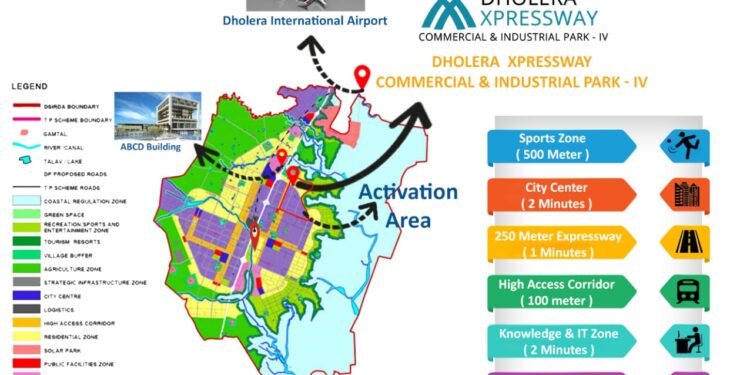
M/s Halcrow UK executed the task of master planning, emphasizing it in the first phase. Moreover, they carefully divided the land into various zones. These included residential, industrial, City Center, High Access Corridor, Knowledge & IT, Logistics, Strategic Infrastructure, Public Facilities, Sports, Recreational and Entertainment, Solar Park, Green Belt, Coastal Regulation, Agriculture, and Village Buffer. Consequently, the master planning revealed a developable area of 422 sq km. They identified this within the total designated 920 sq km for Dholera SIR.
Moving to the next phase, the focus shifted. It now involved designing and planning essential components such as roads, land use, the built environment, water, air, drainage, transportation, communications, and distribution networks.
Additionally, the Gujarati government implemented the Town Planning and Urban Development Act of 1976, known as the TP Act. Later, they created six town planning schemes covering 422 square km of developable land.
Therefore, the development of Dholera Smart City will occur in three stages. This aligns with the progress of these six TP programs.
Town Planning Scheme in Dholera SIR
The Dholera SIR has already notified the six draft town planning projects. Furthermore, they have a planned duration of thirty years. Currently, the process of finalizing TP schemes is underway. As a result, they plan to develop 422 square km out of the available 580 square km. Furthermore, 158 square km is provided for agriculture.
Town Planning 1
Each of the six sub-town Planning schemes in Town Planning 1 holds distinct details. Furthermore, TP 1 has several sub-town Planning schemes designated, including TP 1A1, TP 1A2, TP 1A3, TP 1A4, TP 1A5, and TP 1B. Currently, plan approval for TP1A1 and TP1A2 is underway.

Furthermore, the first town plan encompasses various zones. These include those dedicated to housing, industry, knowledge and technology, green space, solar energy, sports, entertainment, and recreation.
Hence, the villages included in Town Planning 1 are Gogla, Aambli, Bhadiyad, and Kadipur.
Town Planning 2
Seven sub-town Planning schemes collectively form TP 2. Moreover, TP 2A, which is already developed, falls within the Activation Area. Consequently, construction is anticipated to commence on the remaining sub-Town Planning projects by 2022.
Currently, the activation area is simultaneously starting to approve plans. Additionally, the plan approval process has commenced for TP2B1, TP2B2, and TP3B3. However, plan approval will soon begin in TP 2B4, TP 2B5, and TP 2B6.
The zones constituting TP2 include Public Facilities, Green, City Center, Residential, and High Access Corridor. Furthermore, the schemes for Town Planning 2 encompass TP 2A, TP2B1, TP2B2, TP2B3, TP2B4, TP2B5, and TP2B6.
The villages covered by Town Planning 2 are Mundi, Sandhida, Bhimtalav, Rahatalav, Bhadiyad, Gorasu, Otariya, Dholera, Khun, and Bhadiyad.
Town Planning 3
TP 3 comprises zones such as Residential, High Access Corridor, City Center, Green, and Public Facilities Zones. Furthermore, the sub-town planning designs for TP 3 are TP3A, TP3B, TP3C, and TP3D.
Moreover, the villages that are part of Town Planning 3 include Sodhi, Sangasar, Otariya, Sandhida, Dholera, Mundi, Panchi, and Cher.
Town Planning 4
TP 4 includes zones like Residential, Green, City Center, High Access Corridor, and Public Facilities Zones.
Moreover, within TP4, there are sub-Town Planning plans, including TP4A, TP4B1, and TP4B2. Consequently, since TP4A is developed and in the Activation Area, industries can start. Similarly, TP4B1, strategically located along the Dholera expressway scheme, will be developed by 2022.
Consequently, it is one of the most strategically located sub-town Planning plans in Dholera. Additionally, the second phase of Dholera’s development, TP4B2, is expected to be finished by 2032.
The villages that are part of Town Planning 4 include Dholera, Mundi, Panchi, Sandhida, Hebatpur, Zankhi, Bhangadh, and Mahadevpura.
Town Planning 5
TP5A is included in the Dholera expressway plan, and as a result, it is expected to be developed by 2023. Similarly, Sub-Town Planning Schemes TP5A, TP5B, TP5C, and TP5D are part of Town Planning 5.

Additionally, Town Planning 5 includes the villages of Panchi, Bavaliyari, Sodhi, Sangasar, and Hebatpur.
Town Planning 6
Town Planning 6 includes sub-town Planning schemes TP6A and TP6B. Furthermore, the villages falling under Town Planning 6 are Zankhi, Bavaliyari, Bhangadh, Mingalpur, and Hebatpur.
Expressway Development in Dholera SIR
This plan is located on both sides of a 250-meter expressway. It features a 6-lane expressway and 4 lanes designated for the Metro. Furthermore, the 250-meter road is known as the “central spine” of the Dholera project. It plays a crucial role in the overall scheme.
The Dholera Expressway Scheme is set to create eleven sub-town planning projects. Additionally, the ready sub-town planning projects under the Dholera Expressway Scheme include TP1A1, TP1A2, TP2A, TP2B1, TP2B2, TP2B3, TP3A1, TP3A2, TP4B1, TP5A, and TP6A. These projects are part of the Dholera Expressway Scheme.
As the city expands, neighboring villages have the potential to become part of Dholera SIR. Therefore, following the trend in Ahmedabad, where AUDA has included many villages in urban planning, there is a strong possibility. Shiela, Kamataalv, Navagaam, Buranpur, and Pipli will eventually be integrated into Dholera SIR.
For more information contact: 8839440866, 7486003389


